A Train High Above 3rd Avenue

3rd Avenue El Train with the
58th Street station
in the background
as it is approaching
the 65th Street stop,
the terminus.
The history of land, sea and air transportation is so interesting. For 300,000 years people got from one place to another only by walking or swimming. It was only about 6,000 years ago that horses were domesticated. So people could ride from place to place.
Advances in sea & air transportation were just as slow. On water we went from rafts, to sail boats to steam boats (1787). It took until 1825 for steam powered trains to be invented. Trains required tracks so there were limited points that you could reach with them. Bikes had been invented only 8 years earlier.
The first "public" mass land transportation came about with electric powered trolley's in 1880. It took another 5 years for cars to be invented (1885). Ten years later (1895), internal combustion engine buses were introduced.
In Sunset Park, public transportation basically followed this path:
1. On land, horse driven carts and eventually carriages
2. On local waterways, sail boats, row boats and eventually ferries
3. Horse-pulled "trains" on tracks
4. Steam locomotives
5. Electric trolleys
6. Subways
7. Internal combustion engine buses

I am only going to discuss, in depth, the 3rd Ave Elevated train here. But transportation in Sunset Park was influenced by two things.
#1 - The founding of Greenwood Cemetery in 1838. Greenwood quickly became the place to be buried for the rich, famous and elite of New York City and the City of Brooklyn. In addition, the landscaped grounds, ponds and monuments (mausoleums & decorative grave markers) attracted visitors in huge numbers.
#2 - The "pathway" to Coney Island. Coney Islands popularity began as early as 1830 and by 1889 was the most popular amusement area in the United States. A railroad at 65th Street brought visitors from a ferry at 65th to Coney. Another popular route was through the intersection 36th Street & 5th Avenue.
Probably the first important public transportation development in Sunset Park (remember our border is from 17th to 65th and from the water to 8th Avenue) was the opening of an elevated railroad along 5th Avenue. I am willing to bet that very few of you ever knew that there was an el along 5th. Even knowing it, I bet you find it just about impossible to imagine. I know I do.
Coming from the north by Flatbush Avenue, it ran above 5th Avenue and on August 15th, 1889 it reached 25th Street. 36th Street was finally reached on May 29th of 1890.
In 1889, at 36th Street and 5th - where the Jackie Gleason Bus Depot now stands three railroad companies proposed building a major railroad center to be called - "Union Depot". A 125 feet (along 5th Avenue) by 100 feet (east on 36th Street) large structure costing $65,000 that would unite the 5th Avenue and the Coney Island railroad lines. It would allow the passengers to easily switch trains. There would be a ticket taker's office, a large restaurant, liquor saloon, bowling alleys and billiard tables.
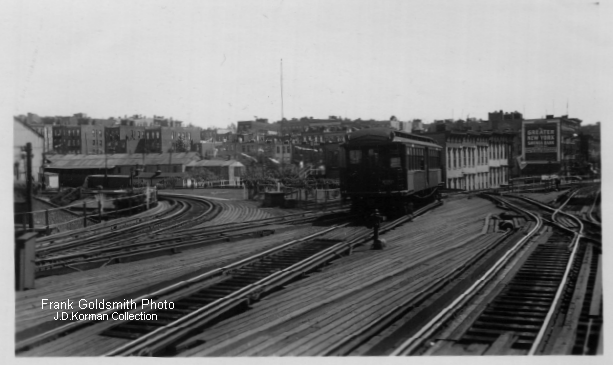
This photo is actually high above the intersection of 5th Avenue & 36th Street. Not only were there tracks for various trains to switch their routes, there were rows of parallel tracks to "store" trains when not being used. It was a small "world" above the world below
Trains coming from the north (downtown Brooklyn) could go no further at 36th Street. They had to either take the Culver line or West End line - a swing to the east going to Coney Island, or a swing to the west heading to 3rd Avenue.
This photo shows the train switching area as viewed from 38th Street. That single train car is heading towards the tracks that lead to 3rd Avenue.
In the middle of the photo, just under the darkness that is the elevated tracks, you will see what look like white poles. Those are some of the supports that held up the many parallel storage tracks above.
Those wires are from the trolley's that ran on 5th Avenue and along 39th Street.


This fantastic photo is another view of the picture above it. Imagine you are standing on the south (where Greenwood is) and looking south towards Bay Ridge. Many of these buildings are still standing. The single car that you see is coming from the 3rd Avenue line. It came up 38th Street and now is coming back onto 5th Avenue.

Here is a look at the Union Depot building just before it was torn down. The strange white silhouette is from a smaller depot building that was torn down.

Here is another shot.

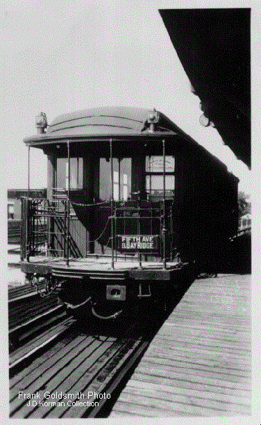
Here is a locomotive from the line. The sign indicates that it goes along the El on 5th Avenue and then swings down 38th Street to continues its run (along 3rd Ave) to its last stop or terminus at 65th Street in Bay Ridge.
Notice that each of the men are sporting mustaches. It was a requirement of the railroad that they grow one - oh come on, I'm just pulling your leg...lol
Here is a similar locomotive. But this one is #12 and the other one was #1.
If you recall, the 5th Ave El reached 36th on May 29th, 1890, five months later on October 1st all the 3rd Avenue stops were opened to the public - 40th, 46th, 52nd, 58th and 65th.
You may know, from movies that locomotives in movies had a "cow catcher" in the front - meant to lessen injury to animals that may stray onto a track. Obviously, they didn't need one on the elevated tracks - the only animals blocking the path wold be an occasional pigeon.


As we leave the 36th & 5th station, let us take one last look from a different angle.
This is behind the building - on the east.
Below is an old transit map. It doesn't show the elevated 3rd Avenue line, but it does show the trolley line on 3rd, the dotted lines show the 65th Street ferry and then you see the railroad lines heading to Coney Island.


This map shows the blocks & lots of blocks from 37th to 40th Street between 5th and 3rd Avenue. Blocks & lots are the official way that the City identifies properties - they do not use the address. In the upper left rectangle we see "block" 700. Each subdivision - mini-rectangles have numbers beginning at one and going up, these are called "lots". Can you find lot number 22? It is a very large rectangle and is colored pink. I believe on this map pink signifies the building is made of brick or masonry. Yellow ones are wood. These are sometimes called insurance maps because insurance companies can use them to see what your building is made of, how big it is and where the fire hydrants are.
Notice the dotted lines going through the auto building. That shows the old route of the Gowanus Road (I marked it with a large blue B and an arrow). If you haven't notice yet, this map is from 1921. Look for the large red A - the arrow shows where the elevated tracks turn from 5th Ave to go down 38th Street. The red B shows where it turns onto 3rd Avenue.
When the el goes along 38th you will see a number of tracks. Those are ground level railroad tracks. Some of them are still there. Did you know, when you travel along 4th Avenue, at 38th Street you are actually going over a bridge with railroad tracks still there, far below.

This modern shot from Google Earth shows the railroad tracks that go under 4th Avenue. These tracks are used today to bring new subway cars onto the line. They come off barges and are brought here at 3rd Avenue (next time you drive along 3rd look for the railroad tracks in the roadway. They off load them from railroad cars onto the subway tracks. Do you see the roof of P.S. 24?

This photo is from the last days of the 3rd Avenue El. With competition from the 4th Ave subway, buses and personal cars they now needed only a single railroad car.
This is on 38th Street and you can see the surface trains below.
This is 38th Street today. The exit ramp of the Gowanus Expressway has replaced the 3rd Avenue El's tracks. But notice you can see the railroad tracks below were brand new and refurbished subway cars some onto the subway track system.
A major problem of the Gowanus is the opposite of the roach motel motto (roaches check in, but they don't check out). With the Gowanus - cars & trucks can get off and congest our streets and spew pollution, but they cannot get back on! They have to drive through Sunset to Bay Ridge or Park Slope to get off our streets.


Here the single elevated car has just left 38th Street and is swinging onto 3rd Avenue. You may notice the surface train yard on the other side of the fence. This was used entirely for freight.
It may take a moment to re-orient yourself. In the previous photo you were "behind" the train, now, we've "run" around to get ahead of it. The view is from us standing on 3rd Avenue and waiting for that single train car to come towards us - got i? Okay...lol
Notice the trolley car approaching us and the cobblestone roadway.
I should mention, there are two tracks above us. 3rd Avenue was not a single track, it was two tracks - one for south bound trains and one for north bound.
Please take note above the trolley, in the distance looks like a ladder. I will mention that again in awhile.


If I haven't confused you enough, now we have moved to 37th Street and are looking south (the previous shot we were on 39th looking north). This gives us a nice view of the path of the El.
See that pointed building? It is still there. It was a bank on the corner of 39th.
And I'm sure you know that Costco is to the right of this photo.
Below we are still looking south and now the building that says Haddan Hall Cigars (this is the pointed building that was once a bank) is now closer to us.
Below is the Haddon Hall Cigars building today


This is another view of 39th Street & 3rd Avenue. In this photo we are looking West towards the waterfront.


Remember me telling you about railroad tracks on 3rd Avenue? Well here they are today. They lead up from the waterfront and they open the gate in that fence ahead to get into the area where the tracks that connect to the subway system can be accessed.
Before we move on, let's take one last look at the curved trackage at 3rd Avenue. This view is looking east towards 38th Street.


The photo to the right is a close-up of the one you saw previously with a trolley coming towards you and a "ladder-like" structure above it. You can see that structure again in this photo.
It is actually a huge antenna owned by RCA for their WNY radio broadcasting/receiving operation. This station actually communicated with ships in the harbor and at sea.

And I especially love this shot (same view as above) that gives us a close-up of the railroad diner - The Ace Diner
Passengers who came from downtown on the 5th Avenue El and then took the 3rd Avenue (towards Bay Ridge) train could get off at 40th Street and switch to the 39th Street & Coney Island Line, the 39th Street and Manhattan Beach Line or the 39th Street and Ulmer Park Line streetcars.

Is there room for one more photo from the north end of the line before we move to the other extreme? This is at 38th Street going east just before turning south.
Sorry that this shot is blurry, but I wanted to include a view of what folks saw back in the day when we looked down a side street - this is 39th Street.


This is the view of the elevated trackage from midway between 3rd & 4th on 39th Street
This is the first passenger station on 3rd Avenue after you came down from 5th Avenue. It is at 40th Street and I believe this is 41st Street.
Below is a view of 45th Street & 3rd Avenue looking northwest. Take note of the barber pole and the old fire alarm box. This photo gives you a good chance to examine the girders and steel work that the el was made of.


This is a look in 1940 at 49th Street. Thank you Linda Krekey for this photo and many of the others. Also, I would like to thank Mellow One's Brooklyn Elevated Railways page and Pete Gelgado and George Conrad for their photos.
I don't want to get too much into issues concerning the demise of the railroad and the building of the Gowanus, but notice how much sunlight could get through to 3rd Avenue compared to now.
You can join me in thanking Jackie Lund for this photo of the 46th Street station of the El. Her photo gave me the push to put this page together.
Here are my comments from Facebook:
I love this photo, it is so crisp. A few things of note:
#1 - I love seeing the trolley below the el on the cobblestone street.
#2 - Ex-lax and Coca Cola were biggie products.
#3 - there is a station or a stop on the el above
#4 - no traffic lights - look at the signage of that era.
#5 - U.S. mailbox on the corner.
#6 - note the kiosk in front of the drug store - could that be the entrance to go up the stairs to the el, looks like another on the other side of the street.
#7 - the building on this side of the avenue was torn down in 1940 along with every other store and apartments upstairs to build the Gowanus Highway (yes not Expressway - it expanded 20 years later).
#8 - the building in the background is still there but the roof edge coping is gone.
Here is the same view in 2017.


Below is the map of the El.


Some differences between 1890 and 2017 - While Greenwood Cemetery was already there, Sunset's Park was not yet in place. Our shoreline was straightened out with landfill and our waterfront park was created from an illegal toxic dumping site. It is interesting to note that Bush Terminal came and went between the two dates.
The Brooklyn Army Terminal was not yet built. The 39th Street Wharf was not yet built. The Owl's Head Water Pollution Control Plant was not yet built. Sunset Park was still a rural, hilly, swampy area for the most part. The bulk of housing was below 3rd Avenue and our shoreline was still under developed.

Here we are looking North from the 58th Street statio
On the left is the train at the last stop on 65th Street. Passengers who wanted to continue on their journey into Bay Ridge could transfer (for a fee) to a trolley.

Above we are looking towards the south - there is no more train track, this is the end of the line. The photo is a little misleading - the tracks look "whited out" I don't know why - it is just the camera. The wood "path" on the left of the photo is a "catwalk" for the workers. Notice how rural the 65th Street area is?
In the photo below we see the incline that allowed street trolley's to climb to the height of the El and pick up passengers. This incline extended into Bay Ridge along 3rd.

At the 65th Street "end of the line" passengers could switch to the Sea Beach Line, the Bay Ridge Suburban Line, Bay Ridge Line, 3rd Avenue Line or 86th Street Suburban Line street cars.
Below are four postcards showing the last stop of the 3rd Avenue El.
Notice the double staircase bringing passengers down from the El. And below the street level is the old Long Island Railroad tunnel under 65th Street. This card is from April 3rd, 1910.

Don't confuse this tunnel below, with the railroad tunnel above.
This is the car tunnel around 67th Street.


And now back to photographs of the era. Here is a view of 3rd Avenue under the last stop at 65th Street


As the label says, this is facing south - those buildings in the distance are just past Bliss Park and a bit east.
This is a view from the railroad tracks in the "valley" or ditch that is 65th Street. The El is seen in the distance. This is 1917.
This ditch was actually a natural feature of the land. Sunset Park had (and still has several) valleys or "hollows" that run east-west. I assume they were formed from the melting water of the glacier 14,000 years ago. There is this one at 65th that continues inland all the way past 8th Avenue, another at 38th that continues into the subway and rail tunnel (and on the other end goes through Greenwood Cemetery).


Another view at the last stop at 65th Street and 3rd Avenue. If you look closely about midway back in the photo you will see fencing along the outside edge of the sidewalk. That is to protect pedestrians from falling to the Long Island Railroad tracks below.
The photograph below, I believe matches the photo to the left, at least approximately. I tried to use the 65th Street rail tunnel as the matching point.
The photo below is looking south as you can see the smoke stacks from the Con Edison electric generation plant. Today, that is the location of the Owl's Head Water Pollution Control Plant


This incredible photo shows the construction of the elevated 65th street station. This is very early in the construction process.
Most of us are familiar with this view as we head to the Belt Parkway. Look close - the El is actually high above the road way bridge.
And below is 1915 when the El was very busy and had a number of train cars.

Obviously in 1915 this beautiful roadway did not lead to the Belt Parkway - the Belt was still many years away. I just read that when Robert Moses introduced the concept of a parkway along the waterfront he called it the "Marginal Boulevard" and then later it became the Circumferential Highway and eventually the Belt Parkway.

I guess you are wondering what happened to the El. Well, in 1914 the subway on 4th Avenue opened and that immediately "stole" lots of riders thanks to its greater distances, speed and some free transfers. Year by year ridership decreased and eventually it was ripe for Robert Moses to snatch up. He built a two lanes in each direction highway on the supports from the former El. In just one year Moses managed to get permission and tear down every store, apartment and building on the east side of 3rd Avenue to expand the roadway. And it expanded again in 1964 to become part of the traffic pattern for the new Verrazano Bridge.

I'm told that the photo of the roadway on the left is from 1954. I assume it is - the smoke stacks on the distant left would be from the Sanitation incinerator on 16th Street. The series of what seems like black water tanks could be on Bush Terminal warehouses. But I'm a bit thrown off by the tall white building in the distance. This may have been mislabeled and is actually a part of the Brooklyn-Queens Highway (Expressway). What I can say is it is very similar to what our Gowanus Highway would have looked like in that year.
This is definitely a 1941 photo of approaching 53rd Street on the right.


Above is the Gowanus Expressway today. It is a financial money pit. It has been under constant repair since 1989 - non-stop. It was supposed to be a quarter billion dollar repair job. I found out about it by accident and contacted the White House Council on Environmental Quality and got a ruling that such a long and costly job (predicted for 8 years) had to have environmental impacts. But the Feds with the help of NYS have ignored all the issues because it is such a great source of money for under the table deals. Road construction has been a source "pay for play" since the 1920's - maybe some day the public will wake up. At the very best, an arterial highway has to be rebuilt every 20 years. We should have torn it down - just like they did with the West Side Highway - a twin of the Gowanus Highway and replace it with an at grade roadway.

The community, especially the businesses that were about to be demolished fought hard but in the end, they lost.
We have lots of photos of the buildings being torn down on 3rd but none of the actual train tracks.
But here is a photo of the 5th Avenue El being taken down on 16th Street in Park Slope. The 5th Ave El & the 3rd Ave El all closed down permanently on May 31st 1940.


Here, on the left, is another view of the el on 5th Ave in Park Slope being razed.
This 1939 photo below shows the 3rd Avenue Trolley coming up 39th by 2nd Avenue.


It seems that the public and the elected officials wanted to get rid of the elevated trains. I can only imagine that the noise and filth from above was no longer seen as part of a needed tranportation system now that they had underground subways
Signing the order to get rid of the Els was viewed as a celebration - signing a Death Warrant for the "criminals".


What I find interesting - almost comical is that this map shows the 3rd Avenue El continuing. But there would be no way to get trains up there once the 38th Street spur was razed.
I can only assume what they really meant was that the structure would not be torn down - that it would be modified into a highway.
I plan to do a future posting on the construction of the Gowanus.
But before that, I must finish the one I've started on Norwegian/Lutheran Hospital.
I am open to your suggestions for other topics!